


At its height in the mid-20th century, American organized crime groups, often called the mafia, grossed approximately $40 billion each year, typically raising that money through illegal or untaxed activities, such as extortion and gambling.
At its height in the mid-20th century, American organized crime groups, often called the mafia, grossed approximately $40 billion each year, typically raising that money through illegal or untaxed activities, such as extortion and gambling.

October 23, 2020
UNIVERSITY PARK, Pa. — Penn State University Libraries will observe GIS Day — an annual event celebrating the technology of geographic information systems (GIS) — with a virtual event from 4 to 5 p.m. on Thursday, Nov. 12.
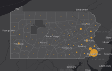
Residents of Pennsylvania can monitor the spread of COVID-19 across the commonwealth with an online dashboard created by researchers at Penn State. The dashboard, which has been available since March 12, provides a map of the state with the number of confirmed COVID-19 cases represented by county.
Updated daily, the dashboard also presents graphics that help to visualize this spread, including ways to look for a “flattening of the curve” that would indicate that our efforts to slow the spread of the virus are working.

Penn State University Libraries will observe GIS Day—an annual event celebrating the technology of geographic information systems (GIS)—on Tuesday, Nov. 12, with activities designed to bring together both new and experienced users of geospatial information across disciplines.

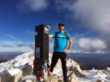
Nicholas Lacey stepped out of the helicopter and into a crowd of people who gathered in anticipation.
The helicopter carried building materials, but for the people of Haiti, who were still suffering from the aftermath of Hurricane Matthew, a devastating Category 5 storm, it was critical material to start rebuilding homes and lives.
Lacey, now a first-year student studying geography at Penn State, served five years in the Marine Corps as a geospatial analyst and took part in a U.S. humanitarian mission to Haiti in 2016.

Penn State University Libraries will celebrate GIS Day on Tuesday, Nov. 13, at an event aimed at the broader Penn State community — students, staff, faculty and community members — who are interested in learning about how geospatial information is being used on campus and beyond.
This year’s program, “Visualizing the World: Connecting the disciplines through geospatial technologies and virtual reality,” explores GIS, geospatial technologies, remote sensing, maps, and location-based applications to foster greater geospatial awareness on campus, within the community, and beyond.
UNIVERSITY PARK, Pa. — Many of Patrick Stephens’ early interests — traveling, hiking, mountain biking — necessitated the use of maps.
Not surprisingly, then, maps themselves became one of those interests, and served as a constant reminder of how much of the world he has left to explore.
“I always liked traveling,” the Penn State and Schreyer Honors College alumnus said. “I never wanted to be tied down to one place. I told myself that if I could make maps, you can make them anywhere in the world. That was always kind of the goal.”
UNIVERSITY PARK, Pa. — Anthony Robinson, assistant professor of geography at Penn State, has been selected to receive a Fulbright grant to teach and conduct research at the University of Salzburg, Austria. Beginning Jan. 2017, Robinson will spend six months working in the Department of Geoinformatics (Z_GIS).
Robinson was awarded a Fulbright for his proposal “Making Maps to Make a Difference: Uncovering Geographic Patterns in Learner Engagement.”